The Unification Epicenter of True Lightworkers
Is Lemuria Returning?
Is the Coral Sea bed rising? Is Lemuria returning?
Ron:
Two tsunami buoys in the Coral Sea off the north east coast of Queensland gave alarms during early April, recording a rapid rise in the ocean floor beneath them. There are no active volcanoes in the Coral Sea area, undersea or above sea level. The buoys in question rode above the deep trench just north of the Coral Sea Islands.
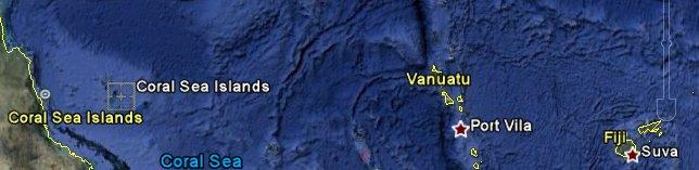
IMAGE: Coral Sea Location - http://www.zetatalk.com/newsletr/issue545.jpg
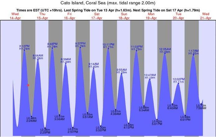
Reports say that Tsunami Station 55023 - STB Coral Sea located at 14.803 S 153.585 E (14°48'9" S 153°35'6" E activated and went into event mode between 20 March and 13 April 2010. The Station was in event mode after the large earthquakes occurred in the area. The event mode was triggered by the buoys' anomalies of water column height above the sea floor. A data search for 20 March to 13 April apparently showed that in 24 days the distance from buoy to sea floor registered by the buoys declined by over 100 meters or 328 feet! That's an average of 13 feet per day since the quakes. The waves on the Cato Island, Coral Sea tide line graph for the period matches the tide lines perfectly so tides were not a factor. See: http://www.zetatalk.com/newsletr/issue546.jpg
The next nearest buoy is over 500 km away and has not been showing data since 17 March 2010. However from 16 March to 17 March its water level readins dropped 39 metres. Is this just a coincidence? And why is this buoy still out of service? A report on God Like Productions (GLP) stated that the last data shown on NDBC Station no. 55012 was:
‘2010 03 17 18 03 00 2 3306.652
2010 03 17 18 02 00 2 3306.996
2010 03 17 18 01 00 2 3306.731
2010 03 16 18 00 00 1 3328.704
2010 03 16 17 45 00 1 3328.670
2010 03 16 17 30 00 1 3328.630
diff of 72 feet in 24 hours!!
has not been on-line since it reached 3289m
that's overall diff of 127 foot.’
Some details of recorded readings for Station 55023 are at end Note 1.
There are only three Tsunami stations listed off the east coast of Australia – two opposite Vanuatu and one in the eastern approaches to Bass Strait. ALL three are listed as having no data in the last 8/24 hours and the two opposite Vanuatu have not had data since 23/4/10! See http://www.ndbc.noaa.gov/index.shtml
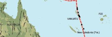
The Coral Sea is near the eastern edge of the Indo-Australian tectonic Plate, somewhat to the west of the Vanuatu Islands. A map showing Vanuatu’s position vis a vis the North Queensland Coast is at: http://www.zetatalk.com/newsletr/issue544.jpg Vanuatu is on the western side of Pacific Ring of Fire and the area around it to the north west, east and south has been very seismically active in the last year or so. Vanuatu itself is said to be currently the most volcanically active area in the world, see for instance the 13’ 38” video at: http://au.tv.yahoo.com/sunday-night/video/-/watch/19084493/http://a...
The city of Cairns is situated on the Queensland coast almost on the same latitude as Vanuatu and slightly south and west of Tsunami Station 55023. The city centre of Cairns is at most two or three metres above sea level and many of its suburbs are also barely above sea level. It is said that the largest tsunamis come from volcanoes. If the Mt Garrat volcanoe*on Gaua Island or any other volcano in Vanuatu blows completely Cairns and much of the Queensland coast would have about two hours warning, provided that the Commonwealth of Australia’s National Oceanic and Atmospheric Administration (NOAA) or other appropriate authorities give that warning immediately. Should Earth changes cause new eruptions to suddenly occur in the Coral Sea the city of Cairns and the adjacent coastal towns and settlements would have very little warning even if NOAA puts its Tsunami stations there back on line and promptly sounds the alarm.
* Mt Garrat is said to have erupted 500 years ago with the climatic effects being felt for two years. A lesser erruption is said to have occurred two decades ago.
The NOAA website [ http://www.ndbc.noaa.gov/index.shtml ] had a Tsunami Station in event mode activated for Station 55023 - STB Coral Sea located at 14.803 S 153.585 E (14°48'9" S 153°35'6" E) on 13 April 2010.
According to his post on GLP Aussie GUY 937531 stated that:
‘… as at 23rd sep 2009 Station 55023 was recording an ocean depth of 4593; this stayed same +/- tides until 5th of April 2010 (Inc 9999's, faulty data).
‘I rang government yesterday while bouy was in active mode.
All of sudden data is removed and bouy reset.
now the (depth/pressure) shows 4413.
Where is the missing data from the 5th til 12th ????
Why was the data removed?’
After inquiries from the public, the NOAA administration responsible for Buoy #55023 announced that it must be defective and would be replaced. NOAA then deleted the data from public view. But more than one buoy was involved in giving the alarm and both buoys apparently recorded similar readings. Buoy #55012 also recorded a drop in the distance between the surface and the ocean floor. The rise in the sea floor was dramatic. A GodlikeProduction thread started intense discussion on the issue. See: http://www.godlikeproductions.com/forum1/message1036933/pg1
It is speculated that the Indo-Australian Plate is moving north-west, colliding with and subducting beneath the Eurasian Plate. See: http://www.risingsunofnihon.com/wp-content/uploads/2009/02/ring-of-... and this movement is allegedly causing the Indo-Australian Plate to tip so that the western half of Australia will sink while the eastern seaboard will rise. However, the rate of movement of the Plate is so slow that it seems unlikely that that subduction is causing the rapid sea level rises recorded in the Coral Sea before the two NOAA buoys were taken off line, or at least their readings no longer made public.
In my view it is more likely that at least parts of Lemuria are beginning to rise with totally uncertain consequences for Australia and especially the east coast. In any event the seismic activity around Vanuatu and along the western boundary of the Pacific Ring of Fire in the southern hemisphere indicates that the east coast of Australia and especially the Queenslanc coast needs to be on alert for possible tsunamis generated there.
#YY MM DD hh mm ss T HEIGHT
#yr mo dy hr mn s - m
2010 04 12 12 59 00 2 4414.176
2010 04 12 12 58 00 2 4413.999
2010 04 12 12 57 00 2 4413.819
2010 04 12 12 56 00 2 4413.694
2010 04 12 12 55 00 2 4413.614
2010 04 12 12 54 00 2 4413.664
2010 04 12 12 53 00 2 4413.501
2010 04 12 12 52 00 2 4413.385
2010 04 12 12 51 00 2 4413.390
2010 04 12 12 50 00 2 4413.327
2010 04 12 12 49 00 2 4413.306
2010 04 12 12 48 00 2 4413.337
2010 04 12 12 47 00 2 4413.306
2010 04 12 12 46 00 2 4413.218
2010 04 12 12 45 00 2 4413.280
2010 04 12 12 44 00 2 4413.312
2010 04 12 12 43 00 2 4413.174
2010 04 12 12 42 00 2 4413.095
2010 04 12 12 41 00 2 4413.167
2010 04 12 12 40 00 2 4413.055
2010 04 12 12 39 00 2 4412.974
2010 04 12 12 38 00 2 4412.933
2010 04 12 12 37 00 2 4412.965
2010 04 12 12 36 00 2 4412.976
2010 04 12 12 35 00 2 4412.935
2010 04 12 12 34 00 2 4412.970
2010 04 12 12 33 00 2 4412.943
2010 04 12 12 32 00 2 4412.971
2010 04 12 12 31 00 2 4413.038
2010 04 12 12 30 00 2 4413.101
2010 04 12 12 29 00 2 4413.177
2010 04 12 12 28 00 2 4413.232
2010 04 12 12 27 00 2 4413.193
2010 04 12 12 26 00 2 4413.096
2010 04 12 12 25 00 2 4413.079
2010 04 12 12 24 00 2 4413.028
2010 04 12 12 23 00 2 4413.060
2010 04 12 12 22 00 2 4413.074
2010 04 12 12 21 00 2 4413.142
2010 04 12 12 20 00 2 4413.100
2010 04 12 12 19 00 2 4413.110
2010 04 12 12 18 00 2 4413.163
2010 04 12 12 17 00 2 4413.163
2010 04 12 12 16 00 2 4413.172
2010 04 12 12 15 00 2 4413.185
2010 04 12 12 14 00 2 4413.155
2010 04 12 12 13 00 2 4413.132
2010 04 12 12 12 00 2 4412.981
2010 04 12 12 11 00 2 4412.942
2010 04 12 12 10 00 2 4412.890
2010 04 12 12 09 00 2 4412.943
2010 04 12 12 08 00 2 4412.957
2010 04 12 12 07 00 2 4412.943
2010 04 12 12 06 00 2 4412.910
2010 04 12 12 05 00 2 4412.862
2010 04 12 12 04 00 2 4412.997
2010 04 12 12 03 00 2 4413.021
2010 04 12 12 02 00 2 4413.079
2010 04 12 12 01 00 2 4413.204
2010 04 05 10 59 00 2 4592.518
2010 04 05 10 58 00 2 4592.518
2010 04 05 10 57 00 2 4592.518
Yes and it apparently can be scrubbed too.
There is much data missing since the last time I checked it last evening. Most significant was the gap in data between 04/05 and 04/08 where the first and largest drop in water column pressure occurred.
I don't know why the data already collected would disappear simply because the unit may not currently be working.
In a way it might be flattering to think maybe somebody may be viewing our little site. The cause and effect of this thread does seem a bit curious.'
Related Article
A rare Earthquake hits Australia. Does this place look familiar? Is a picture emerging?
Views: 43
Comment

© 2026 Created by Besimi.
Powered by
![]()
You need to be a member of Saviors Of Earth to add comments!
Join Saviors Of Earth